 |
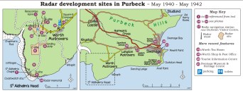 |
| Click on image for map of radar
sites in Purbeck - opens in new browser window. |
|
The maps and photos show you where radar development took
place in Purbeck. Almost nothing is left today except some
foundations on the cliff and a small hut used as a
field studies centre.
There was radar here before the scientists came in 1940.
An early warning radar, called 'Chain Home', was set up on
A-Site; it had two 240ft (75metre) masts for aerials.
When the scientists arrived, they moved onto B-site which
was still being built. A 360ft (110 metre) high steel
tower was also being put up for transmitter aerials on
E-site.
Very quickly, a radar to detect low flying
aircraft was tested on D-site. This was called 'Chain
Home Low' and showed that high cliffs were a good site for
this type of radar.
Until 1940, radar had to have big
aerials because of the wavelength it worked on. The
scientists at Worth were successful in making radars work
on shorter wavelengths so that they needed only small
aerials and could fit easily into aircraft. In August
1940, the first tests of these radars took place with
echoes received back from St Aldhelm's Chapel, an
ancient Norman chapel dating from the 12th century. Later,
the first moving target was tracked by radar - a bicycle
with a researcher sent out to ride it!.
The first
modern 'map-like' radar displays, called a 'Plan Position
Indicator' were built here (back cover photo). This could
show both attacking bombers and defending fighters on the
same radar screen, and made defence against night air
attack effective. This was called 'Ground Control of
Interception'.
A landing strip for aircraft was used for
flights for radar calibration and testing. More
scientists came to Worth, and early in 1941 its management
moved from B-site to Durnford School. Some
experimental work moved from C-site to Leeson House,
and a training centre for radar operators and technicians
was set up in Forres School (now Purbeck View School).
The Germans had also
built radar defences, and in February 1942 British
paratroops raided one of their radars at Bruneval on the
French coast. They brought back key pieces of the radar to
work out how good it was. After this, Churchill thought
that the Germans might raid Worth, and ordered all
radar research to move inland. The scientists hastily
moved to Malvern in May 1942. About 200 people came to
Worth in May 1940; by May 1942 about 2000 people worked
here!
The RAF continued to operate radars at Worth until
well after the war, and the 360 foot (110 metre) tower was
only taken down in the early 1970s.
The scientists enjoyed
a drink at the Square and Compass Inn: they nicknamed
it the 'Sine and Cosine' after mathematical terms they
used in their research. The inn is 300 years old and
several generations of the Newman family have served as
its landlord. Look for the sign 'RAF Worth Matravers' in
the hallway - a relic of the RAF's presence.
There are
other radar sites in Purbeck - two are parts of radio
navigatioin systems used by British aircraft. One was at
Tilly Whim, where Durlston Country Park visitor centre now
is: this was part of the 'Oboe' system. Another, at Brandy
Bay, was part of a system called 'GEE'.
|


